
Geology of Afar Depression
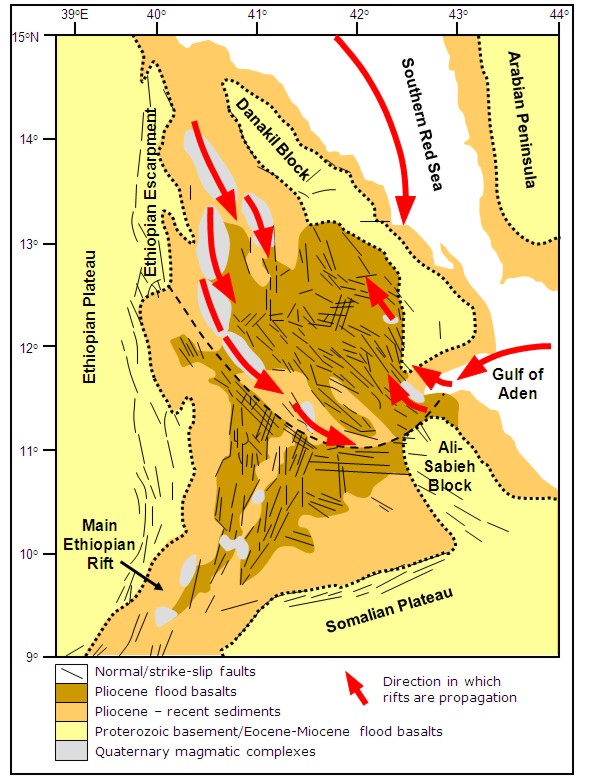
Figure 1: Geological map of Afar showing fault orientations and distribution of the magmatic segments. The red arrows show the direction in which the rifts are propagating. After Barberi & Varet, 1977; Hayward & Ebinger, 1996; Hofstetter & Beyth, 2003 and Rowland et al, 2007.
Geology of the Afar Depression
The Afar Depression is an area of lowland plains split by fault blocks and dotted with shield volcanoes. It is bound to the west by the Ethiopian Plateau and escarpment, to the northeast by the Danakil block, to the southeast by the Ali-Sabieh block and to the south by the Somalian Plateau and escarpment. To the north the southern Red Sea rift is extending down through the Gulf of Zula into the northern Afar Depression, to the east the Gulf of Aden rift is propagating through the Gulf of Tajura into the eastern Afar Depression and to the southwest extension continues through the Main Ethiopian Rift to the East African Rift System (e.g. Beyene & Abdelsalam, 2005) Figure 1.
The overall structural trend across the Afar Depression is for the older larger border faults to be abandoned and for active faulting to be concentrated along narrow zones within the centre of wider rift systems. This is due to the decrease in the strength of the lithosphere with increasing strain rates and magmatism (Hayward & Ebinger, 1996).
The first stage of basin development, during the Oligo-Miocene (29-26Ma), was dominated by long (~60km) high angle border faults.
The second stage (16-7Ma) saw the eastward migration of strain and magmatism to narrow zones within the hinge of the rifts.
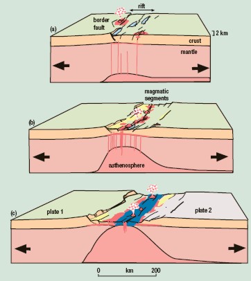
Figure 2: The stages in the development of a volcanic passive margin based on studies of the East African Rift system (Ebinger, 2005).
During the third stage sea-floor spreading style magmatic segments developed within the centre of the rift zones with strain accommodated by dyke injection (Wolfenden et al, 2005).