
Nooner et al, 2009
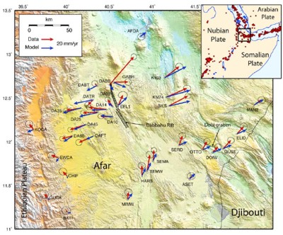
Figure 1: Relief map of northern Afar with the GPS (red arrows) and model (blue arrows) results. The inset shows the location of the study area with the red dots representing the location of earthquakes from 1973 to the present day.
Post-rifting relaxation in the Afar region, Ethiopia by S. Nooner et al, 2009
Non-technical summary
Where the Earth’s crust is being pulled apart by the movement of the tectonic plates, long, thin, vertical sheets of magma (dykes) are intruded from depth. As the magma in the dykes crystallizes it forms new rock. These large dyke intrusions are infrequent and separated by periods of relative quiet when only smaller dykes are intruded. However, for several years after these large rifting events the rate of extension across the region is greater than the movement of the plates. How these dykes are intruded and the type of deformation they cause in the surrounding region is rarely seen. For the first time, GPS measurements were collected within a few months of a rifting event at a major plate boundary, the September 2005, 60 km-long dyke intrusion in the Dabbahu segment, Afar, Ethiopia. Here extension rates for the three years afterwards are greater than the movements of the plates. This is interpreted as due to the upper mantle and crust of the Earth in the region adjusting to the changes brought about by the dyke intrusion. An alternative explanation would be that dykes from magma at great depths within the crust are being intruded. However, since the September 2005 event, only smaller dykes have been observed and these come from the magma sources at shallower depths.
Full paper (PDF file)