
Afar Stratigraphy (non-technical)
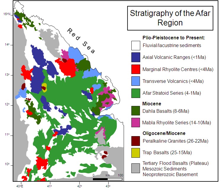
Figure 1: Stratigraphy of the Afar region (after Varet, 1978 and Beyene and Abdelsalam, 2005). Click here for large version.
Stratigraphy of the Afar Region (non-technical)
The oldest rocks of the Afar region are a series of volcanic, and metamorphosed igneous and sedimentary rocks found at the edge of the Afar Depression. They were brought together when east and west Gondwana collided in the late Proterozoic (about 900 million years ago). This formed a stable landmass until the Permian (299-251 million years ago) when Madagascar split away from Africa as the Gondwana landmass began to break up. A shallow sea invaded the area from the Indian Ocean and between the Permian and early Palaeogene (65.5-pre-45 million years ago) laid down marine sandstones and limestones on the continental margins. This was followed by a period of uplift and erosion to a relatively flat landscape.
About 45 million years ago approximately 1km of lavas were erupted across southwest Ethiopia and between about 42 and 22Ma, at roughly the same time as extension in the southern Red Sea and Gulf of Aden, flood basalts (lavas) covered much of the region.
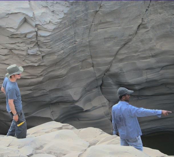
Gorge through older basalts carved out by flash floods. Photograph by David Pyle, University of Oxford.
The flood sequences peaked between about 31-29Ma with the emplacement of up to 2km of lavas and ignimbrites (mix of ash, pumice and rock fragments, indicative of explosive volcanic activity) along the African and Arabian margins of the southern Red Sea. These volcanic rocks are found mainly round the edge of the Afar Depression on the Ethiopian and Somalian Plateau. Where they do occur within the Afar Depression (Trap Basalts - 25-15Ma) they are heavily weathered and cut by faults.
The Miocene (23.3-5.2 million years ago) igneous rocks of the Afar region are divided into the peralkaline granites (rocks that crystallised from magmas within the Earth) (26-22Ma), the Trap Basalts (25-15Ma), the Mabla series (14-10Ma) and the Dahla series (8-6Ma). There are local variations in the timing and distribution of these series. The peralkaline granites are found along the eastern and western edges of the Afar Depression and in the north. They intrude the late Proterozoic rocks, the Mesozoic marine sequences and the older volcanic sequences. The Trap Basalts are part of the flood basalt sequences. They overlie the Mesozoic sediments and are in places intruded by the peralkaline granites. The Mabla Series erupted from north-south trending volcanic vents and consists of lavas and ignimbrites. The Dalha Series consists of basalt flows up to 800m thick with some rare ignimbrites and sedimentary rocks between the flows.
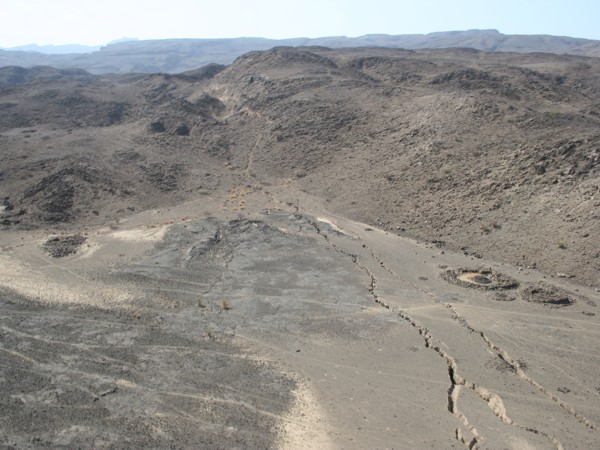
The rift zone to the south of Dabbahu volcano in the Axial Volcanic Ranges. The cracks are in older basalts, softer sedimentary rocks and volcanic ash Photograph by Julie Rowland, University of Auckland.
The most extensive volcanic sequence covering about two thirds of the Afar Depression is the Pliocene-Pleistocene Afar Stratoid Series. Individual lava flows are between 1 and 6m thick and the whole series is up to 1500m thick. It lies above the Dalha Series with a period of erosion and lowered volcanic activity between the two series.
In the east and west of the Afar Depression are the Tranverse volcanics and Marginal centres. These are east/northeast trending volcanic centres around 4 million years old. The Transverse volcanics consist of basalt lava flows with peridotite nodules indicating a source for the lavas within the Earth’s mantle (approximately 33-400km depth). The Marginal centres are calderas (collapsed volcanoes) with lava flows.
The Quaternary Axial Volcanic Ranges are characterised by eruptions from long fissures in the Earth and from shield volcanoes which occur along northwest-southeast trending narrow rift zones(recent lava flows). Their similarities with mid-oceanic ridges have led to the idea that the Axial Volcanic Ranges represent oceanic spreading centres.
Photograph is of the rift zone to the south of Dabbahu volcano in the Axial Volcanic Ranges. The cracks are in older basalts, softer sedimentary rocks and volcanic ash (photo: Julie Rowland, University of Auckland).
The Quaternary sedimentary rocks of the Afar Depression are mainly river/lake deposits with thicknesses up to 200m in places.
For references used, please see technical version.