
News
News
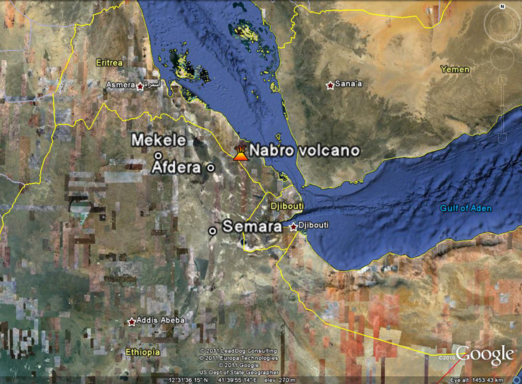
Location of the Nabro volcano
New Eruption in Afar
On Sunday 12th June between 15:30 and 21:50 (local time) a series of magnitude 5 earthquakes were recorded on the Eritrean/Ethiopian border. The source is believed to be an eruption of the Nabro volcano. Local people have been evacuated from the area amid reports of smoke and large rocks falling from the sky. Huge explosions were heard in Afdera 55 miles (90km) and ash falls have been reported in Mekele 150 miles (240 km) west and Semera 130 miles (210km) to the south. The eruption appeared to weaken during Wednesday 15th June but increased activity was seen overnight into Thursday 16th. The SO2 cloud from the inital eruption has now reached China.
Earthquakes are continuing with three magnitude 3 earthquakes on Thursday 16th June and a magnitude 5.5 on Friday 17th June.
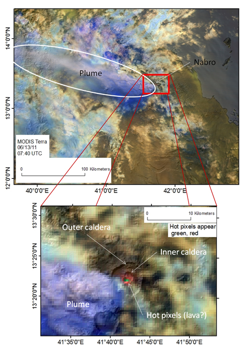
On the left is a false colour short wave infrared image of Nabro volcano and the eruption plume taken on Monday 13th June by the MODIS camera on NASA's Terra satellite. The image is semi transparent and overlain on a detailed shaded model of the Earth's surface, so features in the image can be compared with geographical features. The top panel shows the plume propagating NW from Nabro volcano. The lower panel is zoomed in on the volcano, showing the outer and innner calderas. The pixels covering high temperature features come out red/orange, however very hot material saturates the longer wavelengths, resulting in a green colour. The hot pixels are offset slightly from the inner caldera, but this is probably the result of georeferencing errors.
Below is an animation of the plume of ash and SO2 from the Nabro volcano courtesy of the European Space Agency satellite SEVIRI which collects radiation information from the Earth's surface and atmosphere for meteorological purposes. Captions by Talfan Barnie, University of Cambridge. Animation copyright 2011 EUMETSAT.
Erta 'Ale lave lake overflows (PDF file)
Predicting sites of new volcanic eruptions
A better way to pinpoint where volcanic eruptions are likely to occur has been produced by an international team of geophysicists including scientists from the School of Earth and Environment.
Scientists from the universities of Leeds, Purdue, Indiana and Addis Ababa, investigated volcanic activity occurring in the remote Afar desert of Northern Ethiopia between 2005 and 2009.
By studying a rare sequence of 13 magmatic events – where hot molten rock was intruded into a crack between the African and Arabian plates – they found that the location of each intrusion was not random. They showed that they were linked because each event changed the amount of tension in the earth’s crust.
The findings, published in Nature Geoscience, will help scientists to more accurately predict where volcanic eruptions could strike and contribute to efforts to limit the damage they can cause.
Lead author Dr Ian Hamling, who completed the analysis as part of his PhD in the School of Earth and Environment at the University of Leeds said: “It’s been known for some time that a large earthquake has a role to play in triggering subsequent earthquakes, but until now, our knowledge for volcanic events has been based on isolated cases. We have demonstrated that volcanic eruptions can influence each other. This will help us predict where future volcanic eruptions are likely to happen.”
The team studied the region around a large volcanic dyke - a vertical crack which is created when magma seeps from underground through rifts in the surface of the earth – which erupted in the Afar desert in September 2005.
The magma - hot molten rock - was injected along the dyke between depths of 2 and 9 km, and altered the tension of the earth. The team was able to watch the 12 smaller dykes that subsequently took place in the same region over a four year period.
By monitoring levels of tension in the ground near where each dyke was intruded they found that subsequent eruptions were more likely in places where the tension increases.
Dr Hamling said: “If you look at this year’s eruptions at Ejafjallajokull in Iceland, by estimating the tension in the crust at other volcanoes nearby, you could estimate whether the likelihood of them eruption has increased or decreased. Knowing the state of stress in this way won’t tell you when an eruption will happen, but it will give a better idea of where it is most likely to occur.”
The paper ‘Stress transfer between thirteen successive dyke intrusions in Ethiopia’ by Drs Ian Hamling and Tim Wright of the School of Earth and Environment at the University of Leeds; Eric Calais and Laura Bennati of the Department of Earth and Atmospheric Sciences at Purdue University, Indiana, and Elias Lewi of the Geophysical Obervatory, Addis Ababa University, Ethiopia, is available online in Nature Geoscience.
For more information contact: Press office, University of Leeds, 0113 343 4100, pressoffice@leeds.ac.uk
For an article on the recent volcanic activity in Afar in De Spiegel Online follow the link: http://www.spiegel.de/international/world/0,1518,740641,00.html
MODIS image acquired 21/05/2010 0805UTC, bands 7,2,1 as RGB. Hot lava appears red.
New Eruption, May 2010
A small volcanic eruption has occurred at 12.33N, 40.61E in the Karbahi section of the Manda Hararo (Dabbahu) rift, approximately 2km east of the central crater. Atalay Ayele of the Ethiopian Geophysical Observatory reports that intense seismic activity began at around 2100UTC on 20/05/2010, peaking around 0800UTC on 21/05/2010 before going quiet. SEVIRI radiance time series show lava eruption began around 0115UTC 21/05/2010, peaked around ~03:45UTC and finished by midday. FIRMS reported MODIS instrument aboard NASA’s Aqua and Terra satellites detected thermal anomalies at the eruption site between 0805UTC 21/05/2010 and 0755UTC 23/05/2010. Simon Carn of MTU found a small SO2 plume over the region in OMI satellite observations. A EO-1 hyperion image commissioned by Ashley Davies at JPL and acquired on the morning of the 22nd shows a very small lava flow less than 0.25 km2 in area. Gezahegn Yirgu of AAU reports that eyewitnesses saw plumes of smoke and flowing lava.
The eruption is the fourth to have occurred in the Dabbahu rift since a major rifting episode began in September 2005. It is the fourteenth episode of tectonic/volcanic unrest to date – the others having resulted in the underground intrusion of magma. Activity in Afar remains similar in pattern to the Krafla rifting episode (Iceland, 1975-1984). If this similarity continues, we expect larger eruptions to occur over the next few years.
EO-1 Hyperion image acquired on the morning of 22/05/2010. Bands in the visible to near infrared show the fresh lava as a dark blue/black colour. Image credit: NASA/JPL/GSFC/EO-1 MSO/Ashley Davies. This image was obtained by the NASA Earth Observing 1(EO-1) spacecraft. EO-1 is managed by the NASA Goddard Space Flight Center. EO-1 is the remote sensing asset of the JPL/GSFC Volcano Sensor Web, which detects and tracks volcanic eruptions around the world.
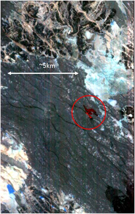
EO-1 Hyperion image acquired on the morning of 22/05/2010. Bands in the short wave infrared register thermal radiation from the cooling lava, giving the flow a red colour. Image credit: NASA/JPL/GSFC/EO-1 MSO/Ashley Davies. This image was obtained by the NASA Earth Observing 1(EO-1) spacecraft. EO-1 is managed by the NASA Goddard Space Flight Center. EO-1 is the remote sensing asset of the JPL/GSFC Volcano Sensor Web, which detects and tracks volcanic eruptions around the world.
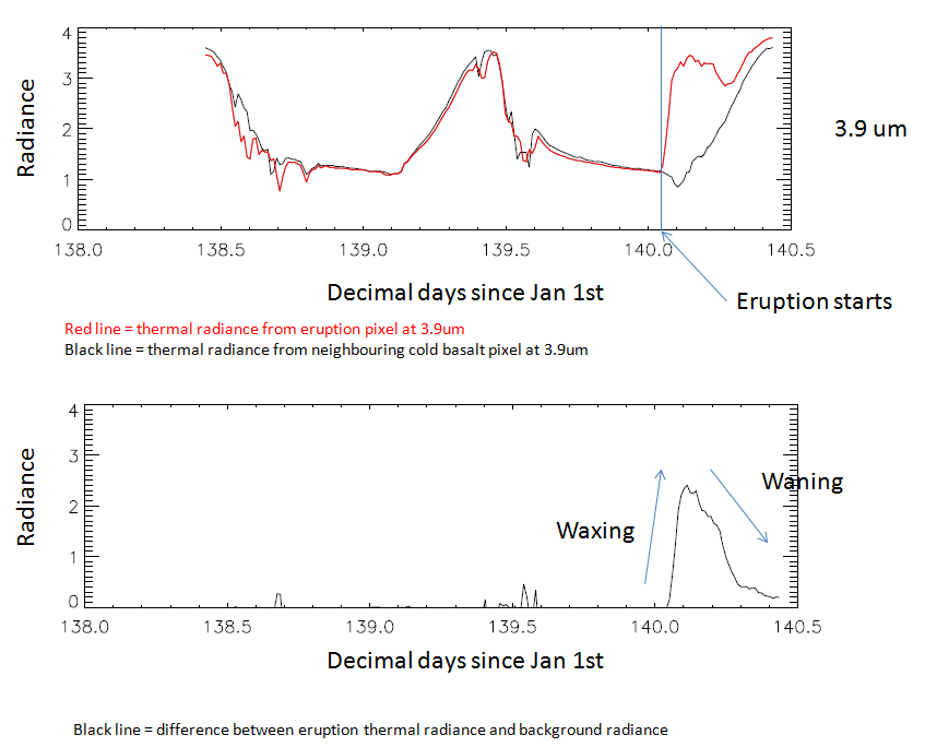
SEVIRI radiance time series showing radiant output from the eruption. Data courtesy EUMETSAT.