
Hamling et al 2009
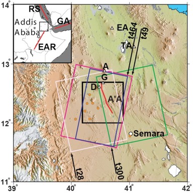
Figure 1: Colour shaded relief map of northern Afar. Main figure shows the location of the dyke (red line) intruded in 2005, Gabho (G), Dabbahu (D), Alayta (A), Ado’Ale (A’A), Tat’Ale (TA) and Erta’Ale (EA) volcanoes (white triangles) and Semara, the regional capital (white circle). The coloured boxes indicate the available InSAR coverage—tracks 28 (green box), 49 (pink box), 300 (white box) and 464 (blue box). Orange circles indicate the continuous GPS stations used in the joint inversion of InSAR and GPS data. The Manda–Hararo segment runs from Dabbahu to Semara.
Geodetic observations of the ongoing Dabbahu rifting episode: new dyke intrusions in 2006 and 2007 by I.J. Hamling et al, 2009
Non-technical summary
In September 2005 a swarm of earthquakes and volcanic eruptions in the Afar region marked the beginning of a new episode of rifting along the plate boundary. These earthquakes and eruptions were associated with the intrusion of a 60km-long dyke along the Dabbahu magmatic segment (figure 1). The magmatic segment is an area marked by a series of volcanoes where the pulling apart of the plates is concentrated. A dyke is a vertical injection of magma from deep in the Earth’s crust. As the magma in the dyke crystallizes it forms new rock and so accommodates the movement of the plates.
The area around the new dyke was monitored from June 2006 using Satellite Radar Interferometry (InSAR), data from Global Positioning System (GPS) instruments and seismometers. InSAR is a widely used technique for monitoring changes of the Earth’s surface. It measures variations in distance, to within a centimetre, between the satellite and the Earth’s surface and so is used to show changes in the height of the ground. The GPS instruments continuously record data on their position and the seismometers measure and record ground movements.
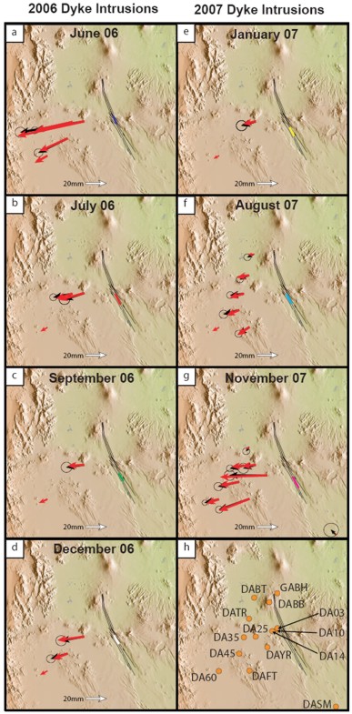
Figure 2: Observed and modelled GPS data covering each of the new dyke intrusions (a–g). Black arrows show the observed GPS displacements. Red arrows show the corresponding modelled displacements from the InSAR and GPS data. Black lines show the location of the dyke model, coloured lines show the location of the individual dykes. (h) Location of all continuous GPS sites around the Dabbahu rift segment.
The information collected between June 2006 and December 2007 show a series of new dykes have been intruded along the same lines of weakness as the first dyke but in areas less affected by the original dyke opening (figure 2). These new dykes are between 0.5 and 2m wide, up to about 10km long and lie within the top 10km of the Earth’s crust.
The August 2007 intrusion was associated with an eruption of magma from a 5km long fissure in the ground. InSAR data show that for the September 2005 dyke the ground around the Dabbahu volcano subsided suggesting that the magma chamber beneath this was the source of the magma for this dyke. The rise in the ground around the Ado’Ale volcanoes in the centre of the rift, the change in location of seismicity during the dyke intrusions and the movement of the ground away from the newer dykes suggests there is now a magma source under the centre of the rift segment.
The sequence of dyke intrusions observed so far is similar to that seen in Iceland during the Krafla rifting episode. This lasted nine years from 1975 to 1984 and so it is predicted that eruptions in Afar are likely to become more frequent before this rifting episode is over.
Full paper (PDF file)