
Guidarelli et al 2011
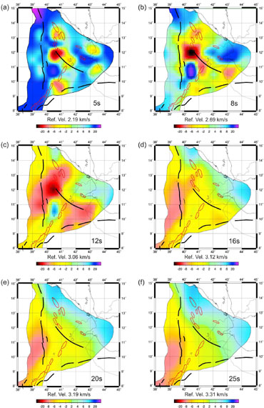
Figure 1. Velocity maps of the Afar region at different time slices through the lithosphere. Major faults are marked as black lines.
Surface wave tomography across Afar, Ethiopia: Crustal structure at a rift triple-junction zone by M. Guidarelli et al, 2011
Non-technical summary
Tomography maps of the Earth's crust and upper mantle (the lithosphere) show the velocity of seismic waves generated by earthquakes and are used to infer the composition, thickness and temperature of the rocks the waves have passed through: where the lithosphere is cooler and/or thinner, seismic waves travel more quickly and where it is warmer and/or thicker the waves travel more slowly.
This paper uses seismic wave data from the Afar region to create tomography maps of the top 30km of the lithosphere. These maps reveal the nature of the crust and upper mantle across the Afar triple-junction, picking out areas where the crust has oceanic characteristics and areas where continental crust is intruded by magma. It also shows variations in the thickness of the crust, with thickened crust beneath the western border faults of Afar on the Ethiopian plateau and the crust thinning progressively across the Afar region from west to east. Low velocity zones beneath the recently active Afdera - Erta'Ale, Dabbahu-Manda Hararo and Ayelu-Amoissa volcanic areas indicate the presence of partial melt between ~6-12km and suggests the lower crust contains significant amounts of partial melt for long periods after individual volcanic and dyking events.
Full paper (PDF file)