
Field et al 2012
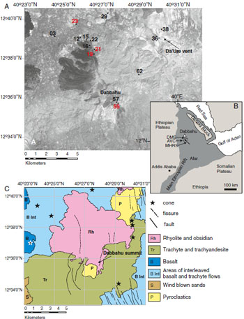
Figure 1: A) Satellite image of Dabbahu. The prominent dark flows in the NW and around the summit are obsidians and represent the youngest volcanic activity in the area. Numbers in red denote samples used for melt inclusion analysis, those in white, matrix glass analysis. B) Location map of Dabbahu and the Manda Hararo Rift Segment (MHRS). C) Simplified geological map based on Barberi et al. (1974a).
Magma storage conditions beneath Dabbahu Volcano (Ethiopia) constrained by petrology, seismicity and satellite geodesy by L.Field et al, 2012
Non-technical summary
Dabbahu volcano is situated in a remote area of northern Ethiopia. There are no recorded eruptions of Dabbahu itself in historical times. However, evidence shows that large eruptions have occurred during the volcano's past and active fumaroles and earthquakes centred beneath Dabbahu indicate the volcano is still active. This study attempts to further understanding of the magma storage beneath Dabbahu volcano and thus future eruptions, by integrating the petrology of the lava flows with seismic and satellite data.
Petrological work involved studying the gases trapped within larger crystals in the solidified lava. This allowed analysis of the temperatures and pressures, and therefore depth, at which the magma was stored prior to eruption. These indicated a magma chamber between about 1-5km in the crust.
Seismological studies looked at the distribution of earthquakes beneath Dabbahu. Earthquakes occur around the margins of magma chambers due to the high pressures and associated fracturing in the surrounding rocks. The seismic data showed abundant earthquakes at less than about 2km beneath Dabbahu suggesting fracturing of the rocks above a magma chamber. There were no earthquakes between 2 – 6km indicating the presence of magma. Below 6km earthquakes were less frequent and the presence of magma less clearly defined.
These petrology and seismic data were then used to produce a series of models which could be matched to satellite (InSAR) data of the area. InSAR measures variations in distance between the satellite and the Earth's surface and so is used to show changes in the height of the ground. In this case, changes in the height of the ground would be due to the movement of magma at depth in the crust.
The result of integrating these three studies was that magma was found to lie in a series of stacked sills (horizontal magma bodies) between 1-5km below sea level and connected by a series of conduits or dykes. These magma chambers appear long-lived and appear to have maintained a stable geometry over the past few thousand years.
Full paper (PDF file)