
Ayele et al 2009
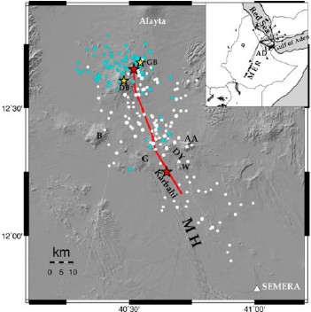
Figure 1. Earthquake distribution during the Sept. 4 to Oct. 4, 2005 episode in the Manda-Harraro rift. The red line shows the surface projection of the dyke. Light blue circles represent earthquakes between Sept. 4–24 and white circles between Sept. 25 to Oct. 4. Circle size is scaled to magnitude. Yellow stars represent the Dabbahu (DB) and Gab’ho (GB) volcanoes while the red stars represent the eruption at Da’Ure and in the Karbahi graben. AA (Ado Ale), DY (Diyilu), G (Gommoyta), B (Badi), W (Wa’lis) and MH (Manda-Harraro rift zone). Inset: Major tectonic features in the Afro-Arabian rift system and seismic stations (triangles) used in this study..
September 2005 mega-dike emplacement in the Manda-Harraro nascent oceanic rift (Afar depression) by A. Ayele et al, 2009
Non-technical summary
Information obtained from the study of seismic data, recorded both regionally and locally, can be used to determine how the Afar region is deforming as the plates pull apart (figure 1). Seismic data are records of the waves of energy created by earthquakes. These waves travel through the Earth and are picked up by stations at the surface. In Afar depression these data have been used to locate the likely magma sources for the September 2005 dykes in the Manda-Harraro rift zone (a dyke is a vertical injection of magma from deep in the Earth’s crust). As the magma in the dyke crystallizes it forms new rock and so accommodates the movement of the plates. The results show there are three centres from which the dykes have originated: two around the Dabbahu Gab’ho Volcanic Complex (DVC) and the third at the Ado’Ale Volcanic Complex (AVC) (figure 2). The seismic data show the AVC is the largest of these sources and that the dykes migrated northward at an average rate of 15-30cm per second. This is slower than speeds observed for dykes in Krafla, Iceland, but faster than some mid-ocean ridges (these are long ridges beneath the oceans where plates have been moving apart for tens of millions of years). The rift landscape observed in Afar, which is dominated by lines of volcanoes and fissures, is similar to that of mid ocean ridges and it is likely that the Afar region will go on to become a fully developed ocean ridge in the future.
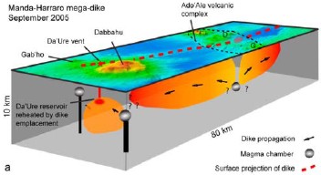
Figure 2. Cartoon interpretation of the volcanic system activated in the Manda-Harraro rift during the Sept. 2005 episode. Dykes are shaded orange. Grey shaded ellipses show magma chambers that fed the dykes.
Earthquake activity related to the dyke intrusions in this region of Afar follows a period of decades, if not centuries, of quiescence. Earthquakes were first noticed in April around the DVC and then during the September episode activity jumped from the DVC to around the AVC. It maybe the early activity in the DVC area destabilised the magma chamber beneath the AVC leading to the formation of the larger dyke episode. Figure 2 shows the three separate magma sources as well as the way the dykes intruded between the two volcanoes. Dyke intrusion and so the opening of the crust was concentrated beneath the valley between the two volcanic centres. This shows the complicated plumbing mechanisms of the magma chambers and how they relate to the rifting movements across the area.
Full paper (PDF file)