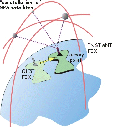
 The
Global Positioning System is based on a "constellation" of satellites
that emit timed signals. Developed as a navigation (and weapons guidance) aid,
GPS is now used as a very precise surveying tool. Under good conditions (and
repeated fixes over several days), sites can be located within 2 cm. So repeat
surveys over several years can determine accumulated plate motion. On this site
there are examples of rotation of a single plate (Antarctica)
and displacement fields within the deforming Anatolian/Aegean
area.
The
Global Positioning System is based on a "constellation" of satellites
that emit timed signals. Developed as a navigation (and weapons guidance) aid,
GPS is now used as a very precise surveying tool. Under good conditions (and
repeated fixes over several days), sites can be located within 2 cm. So repeat
surveys over several years can determine accumulated plate motion. On this site
there are examples of rotation of a single plate (Antarctica)
and displacement fields within the deforming Anatolian/Aegean
area.
Active tectonics