A brief history of the Messinian on Sicily
Rob Butler
|| Messinian Salinity Crisis front page || Gallery of the Messinian on Sicily ||
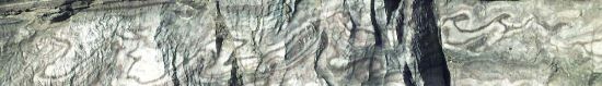
Click on an image to go to a larger version with caption. For lots of photographs go to the gallery.
 The ‘Salinity
Crisis’ in the Mediterranean represents one of the most dramatic examples environmental change
outside of glaciated areas in the relatively young geological record. In the 1970s, deep sea drilling
confirmed that sediments beneath the floor of the Mediterranean included a layer of salt. For these
researchers, the salt layer, sandwiched between sediments that had been deposited under very deep water
conditions, implied one thing: the Mediterranean had once dried up.
The ‘Salinity
Crisis’ in the Mediterranean represents one of the most dramatic examples environmental change
outside of glaciated areas in the relatively young geological record. In the 1970s, deep sea drilling
confirmed that sediments beneath the floor of the Mediterranean included a layer of salt. For these
researchers, the salt layer, sandwiched between sediments that had been deposited under very deep water
conditions, implied one thing: the Mediterranean had once dried up. 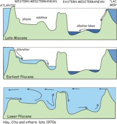 It
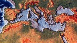
was well known from plate reconstructions that Africa and Europe had moved together to isolate what
was once the open Tethys ocean into the restricted Mediterranean by the end of Miocene times (the Messinian
stage, about 7-5 million years ago). The isolation was completed by a sea-level fall of world-wide extent
(linked to a resurgence in glaciation) that cut off the Mediterranean from the Atlantic. The isolated
sea was then thought to have dried out, only filling when the world sea-level rose again during global
warming at the start of Pliocene times. Rough calculations estimate that with no river input an isolated
Mediterranean would evaporate in a few tens of thousands of years, given the arid climates that characterise
glacial maximums. Refilling by the Atlantic pouring back in through a breached Gates of Gibraltar might
take a little longer.
It
was well known from plate reconstructions that Africa and Europe had moved together to isolate what
was once the open Tethys ocean into the restricted Mediterranean by the end of Miocene times (the Messinian
stage, about 7-5 million years ago). The isolation was completed by a sea-level fall of world-wide extent
(linked to a resurgence in glaciation) that cut off the Mediterranean from the Atlantic. The isolated
sea was then thought to have dried out, only filling when the world sea-level rose again during global
warming at the start of Pliocene times. Rough calculations estimate that with no river input an isolated
Mediterranean would evaporate in a few tens of thousands of years, given the arid climates that characterise
glacial maximums. Refilling by the Atlantic pouring back in through a breached Gates of Gibraltar might
take a little longer.
 Central
to the development of these dramatic models were the on-land outcrops of Miocene strata on the island
of Sicily. Messinian halite and potash salts together with gypsum had long been exploited commercially
with over 800m of salt thickness in some basins. These deposits are classically separated into two cycles
separated by a sub-aerial unconformity.
Central
to the development of these dramatic models were the on-land outcrops of Miocene strata on the island
of Sicily. Messinian halite and potash salts together with gypsum had long been exploited commercially
with over 800m of salt thickness in some basins. These deposits are classically separated into two cycles
separated by a sub-aerial unconformity. 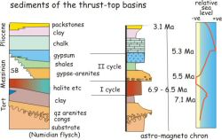 The
First Cycle includes high order evaporites (chlorides) and organic-rich facies while the Second Cycle
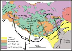
contains clastic evaporites and selenitic gypsum. Linked structural and stratigraphic studies
in central and southern Sicily show that the evaporites accumulated in synclines related to underlying
thrust structures of the frontal part of the Maghrebian orogenic belt.
The
First Cycle includes high order evaporites (chlorides) and organic-rich facies while the Second Cycle
contains clastic evaporites and selenitic gypsum. Linked structural and stratigraphic studies
in central and southern Sicily show that the evaporites accumulated in synclines related to underlying
thrust structures of the frontal part of the Maghrebian orogenic belt. 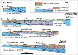 This
orogen runs through north Africa (geologically, SE Sicily is part of the African foreland) and links
into the southern Apennines of Italy. Prior to the Salinity Crisis these basins were hydrodynamically
linked through the foredeep to the Mediterranean.
This
orogen runs through north Africa (geologically, SE Sicily is part of the African foreland) and links
into the southern Apennines of Italy. Prior to the Salinity Crisis these basins were hydrodynamically
linked through the foredeep to the Mediterranean.
The precursor sediments (Terravecchia Formation) formed a delta, sourced from the north. The crests
of anticlines have late Tortonian-early Messinian patch reefs upon them. The synclines that host the
Mesinian evaporites formed a tiered system, with originally shallow water in the north to progressively
deeper water in the south. 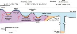 Thus
Sicily provides an ideal 'tide gauge' for charting how the level of the Mediterranean sea fell during
the Messinian: this regression acted on a range of paleobathymetries, shallow in the north and progressively
deeper in the south, locally complicated by active thrust structures. The prediction is that the northern
synclines experienced more restricted sea water circulation while those in the south were submerged
beneath open water. Consequently the first evaporites should form in the north, getting progressively
younger to the south.
Thus
Sicily provides an ideal 'tide gauge' for charting how the level of the Mediterranean sea fell during
the Messinian: this regression acted on a range of paleobathymetries, shallow in the north and progressively
deeper in the south, locally complicated by active thrust structures. The prediction is that the northern
synclines experienced more restricted sea water circulation while those in the south were submerged
beneath open water. Consequently the first evaporites should form in the north, getting progressively
younger to the south.
 The
types of evaporite facies vary over very short distances across the Sicilian folds. Anticline crest
show evaporitic carbonates with lime muds and local sabbkha-like textures. In general these successions
are about 10m thick and show bed-by-bed brecciation and collapse. These features suggest that sea level
was oscillating, leaving anticline crest sometimes a few metres below sea level and sometimes exposed
to meteoritic water and karstification. In contrast, mine data show that the synclines contain vast
thicknesses, locally over 500m, of halite and potash salts.
The
types of evaporite facies vary over very short distances across the Sicilian folds. Anticline crest
show evaporitic carbonates with lime muds and local sabbkha-like textures. In general these successions
are about 10m thick and show bed-by-bed brecciation and collapse. These features suggest that sea level
was oscillating, leaving anticline crest sometimes a few metres below sea level and sometimes exposed
to meteoritic water and karstification. In contrast, mine data show that the synclines contain vast
thicknesses, locally over 500m, of halite and potash salts. 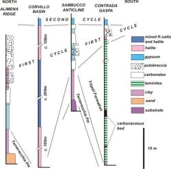 The
flanks of the folds commonly contain gypsum. Thus the evaporitic facies are fractionated depending on
the structural position. The simple explanation is that outlying anticlines act as a porous barrier
within which the less soluble salts accumulate, leaving water enriched in the more soluble halite and
potash salts to pass into the syncline where they are deposited. Therefore structural architecture and
evolution of the Messinian basins on Sicily exerts a fundamental control on the stratigraphy.
The
flanks of the folds commonly contain gypsum. Thus the evaporitic facies are fractionated depending on
the structural position. The simple explanation is that outlying anticlines act as a porous barrier
within which the less soluble salts accumulate, leaving water enriched in the more soluble halite and
potash salts to pass into the syncline where they are deposited. Therefore structural architecture and
evolution of the Messinian basins on Sicily exerts a fundamental control on the stratigraphy. 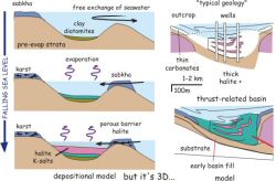 Thrusting
provides accommodation space for evaporites and also controls the water pathways into the desiccating
basins.
Thrusting
provides accommodation space for evaporites and also controls the water pathways into the desiccating
basins.
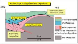
Mine and outcrop data show that the Messinian evaporites contain an important inter-regional unconformity (a classic example of a ‘type 1 sequence boundary’ in sequence stratigraphic terminology). This surface separating First and Second Cycle evaporites is related to the forced regression associated with the acme of Mediterranean desiccation, an interpretation supported by local ravinement and incised valley fills. The overlying ‘Second Cycle’ evaporites are a combination of detrital, reworked First Cycle material and primary gypsum formed under brackish water. Regional onlap relationships and bed continuity suggest that this water body was of regional extent, with a systematically rising baselevel. The Second Cycle evaporites mark the replenishment of baselevel to near normal sea levels. However, normal sea water conditions, as charted by a rich fauna, only occurs later, at the onset of the Pliocene. These younger strata are typically chalks (the Trubi Formation) that shows regional transgressive behaviour on substrata.
By linking tectonic and sequence stratigraphic analyses to facies distributions across the Sicilian
basins it is possible to build up a picture of sea level variations and climatic fluctuations. However,
the absolute timing of these events and the rates of the processes requires additional data. 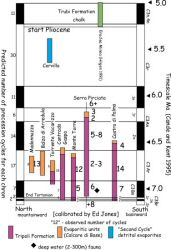 As
part of a regional study of deformation rates (The central Sicily Basins Project, funded by the UK’s
Natural Environment Research Council), high resolution stratigraphic data were collected. For these
types of problems, traditional palaeontological approaches are of little use. First, they rarely provide
the necessary temporal resolution. Second, and more crucially, they are environmentally sensitive. Not
much lives in the saline world of a halite basin. So our approach relies on linking magnetostratigraphy
to depositional cyclo-stratigraphies. Sediments can record reversals in the polarity of the Earth’s
magnetic field (rather like ocean floor magnetic anomalies chart sea-floor spreading). However, to calibrate
reversals in measured sections with the world-wide reversal record requires additional controls. We
use the fact that reversals represent different periods of time. Neogene marine sediments in the Mediterranean
commonly show cyclic variations that have been matched to regular fluctations in earth orbit. These
precession cycles have a period of about 24,000 years. Consequently by counting cycles we can sum the
duration of time and calibrate the duration of our measured magnetostratigraphic section. This in turn
can be matched against the global record. Potentially the method can give a temporal resolution of a
single precession cycle (24,000 years) even for sediments several million years old.
As
part of a regional study of deformation rates (The central Sicily Basins Project, funded by the UK’s
Natural Environment Research Council), high resolution stratigraphic data were collected. For these
types of problems, traditional palaeontological approaches are of little use. First, they rarely provide
the necessary temporal resolution. Second, and more crucially, they are environmentally sensitive. Not
much lives in the saline world of a halite basin. So our approach relies on linking magnetostratigraphy
to depositional cyclo-stratigraphies. Sediments can record reversals in the polarity of the Earth’s
magnetic field (rather like ocean floor magnetic anomalies chart sea-floor spreading). However, to calibrate
reversals in measured sections with the world-wide reversal record requires additional controls. We
use the fact that reversals represent different periods of time. Neogene marine sediments in the Mediterranean
commonly show cyclic variations that have been matched to regular fluctations in earth orbit. These
precession cycles have a period of about 24,000 years. Consequently by counting cycles we can sum the
duration of time and calibrate the duration of our measured magnetostratigraphic section. This in turn
can be matched against the global record. Potentially the method can give a temporal resolution of a
single precession cycle (24,000 years) even for sediments several million years old.
 Our
results from a range of sites across Sicily show that the onset of evaporite accumulation was diachronous.
Calibrating the magnetostratigraphy shows that the fall of Mediterranean sea level was protracted. The
earliest evaporites in our study accumulated early in chron C3Ar (pre 6.88 Ma) and the youngest accumulated
late in chron C3An (post 6.0 Ma).
Our
results from a range of sites across Sicily show that the onset of evaporite accumulation was diachronous.
Calibrating the magnetostratigraphy shows that the fall of Mediterranean sea level was protracted. The
earliest evaporites in our study accumulated early in chron C3Ar (pre 6.88 Ma) and the youngest accumulated
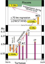
late in chron C3An (post 6.0 Ma). 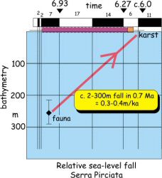 During
this period the basinward (southward) shift in coast line was 70 km and in vertical section implies
a relative fall in sea level at 0.3-0.4 m/ka. The lowest point in the level of the Mediterranean (so-called
low stand) probably finally occurred at 5.8-5.5 Ma.
During
this period the basinward (southward) shift in coast line was 70 km and in vertical section implies
a relative fall in sea level at 0.3-0.4 m/ka. The lowest point in the level of the Mediterranean (so-called
low stand) probably finally occurred at 5.8-5.5 Ma.
Transgression marked by accumulation of the 'second cycle' deposits, which all record reversed magnetisations (C3r), apparently occurred far more rapidly (200 ka), prior to the return to 'normal' marine conditions in the central Mediterranean (Trubi deposition) late in chron C3r. So far a unified bio- astro-magneto-stratigraphy has proved impossible. Assuming depositional cyclicity in the first cycle and precursor sediments are eustatic in origin and forced by precession, they provide an absolute calibration of magnetostratigraphy. Discrepancies with conventional biostratigraphy require diachronous colonisation and extinctions between sub-basins. Such diachroneity in biological 'events' should be expected during large magnitude sea level fluctuations and their associated local variations in water chemistry within isolated basins.
The Sicily study then gives a new insight onto the salinity crisis. For most of the Messinian the level of the Mediterranean fell slowly, linked to the fall in world ocean level caused by a sharp glacial event. The seaways stayed open. If the Mediterranean itself dried up then this happened only for a short period in the late Messinian. However, much of the evidence for the nature of the Mediterranean basin floor during this time came from Sicily – clearly an area that never resided at these depths. Although the water returned across Sicily in the latest Messinian at a much faster rate than it fell, it still did so over a protracted period. There no evidence for a catastrophic flooding at the start of the Pliocene. Rather, this time represents a change in water chemistry accompanied by a sea level rise and recolonisation by a richly diverse fauna. The nature of the Mediterranean water body during the late Messinian is controversial Our existing studies suggest that it was not normal world ocean water but had a significant component of river input. It was however homogeneous across the Sicilian basins suggesting that these synclines had good communication with the broader sea.
This story of structure and sedimentation illustrates how a multidisciplinary approach to basin analysis can yield high resolution results. It is now possible to quantify rates of geological processes with surprisingly high precision. However, to have much further faith in these models and results requires a broader view and the application of these methods to other circum-Mediterranean sites. Fortunately there are many to target and work is continuing apace.
The members of the Central Sicily Basins Project included Mario Grasso and Rosanna Maniscalco (University of Catania), Buffy McClelland and Bryan Finegan (Oxford University), Martin Pedley (Hull University) and Henry Lickorish, Ed Jones, Shona Keogh and I (University of Leeds). Thanks to them all! The project was NERC funded.
For a regional bunch of information on the Messinian in the Mediterranean why not try Marco Roveri's Messinian web pages.
Butler, R.W.H. & Lickorish, W.H. 1997. Using high resolution stratigraphy to date fold and thrust activity: examples from the Neogene of South-central Sicily. J. Geol. Soc. London 154, 633-643.
The structural side of the story, using the stratigraphy to get deformation rates.
Butler, R.W.H., Lickorish, W.H., Grasso, M., Pedley, H.M. & Ramberti, L. 1995. Tectonics and sequence stratigraphy in Messinian basins, Sicily: constraints on the initiation and termination of the Mediterranean 'salinity crisis'. Bull. Geol. Soc. America 107, 425-439.
The description of the sequence stratigraphic model for Sicily – predicting diachroneity.
Butler, R.W.H., Keogh, S.M. & Lickorish, W.H. 1998 (appeared 2000). Evolution of the Agrigento thrust-top basin, Sicily: Sedimentation and the tectonics of orogenic wedges. Annales Tectonicae 12, 28-50.
A description of part of the basins – in a volume with lots of other Messinian articles.
Butler, R.W.H., McClelland, E. & Jones, R.E. 1999. Calibrating the duration and timing of the Messinian Salinity Crisis in the Mediterranean: linked tectono-climatic signals in thrust-top basins of Sicily. J. Geol. Soc. London, 156, 827-835.
The magnetostratigraphic data that tests the diachroneity model – giving relative rates of sea-level changes in the Mediterranean – the source for Figure 2. Other Messinian articles in the issue, including….
Keogh, S.M. & Butler, R.W.H. 1999. The Mediterranean water body in the late Messinian: interpreting the record from marginal basins on Sicily. J. Geol. Soc. London, 156, 837-846.
Using strontium isotope studies to look at mixing of water between sub-basins, the Mediterranean and world’s oceans.
The following two papers can be used to get a flavour of the tectonic setting:
Lickorish , W.H., Grasso, M., Butler, R.W.H., Argnani, A. & Maniscalco, R. 1999. Structural styles and regional tectonic setting of the 'Gela Nappe' and frontal part of the Maghrebian thrust belt in Sicily. Tectonics, 18, 655-668.
Speranza, F., Maniscalco, R., Mattei, M., Di Stefano , A., Butler, R.W.H. & Funiciello, R. 1999. Timing and magnitude of rotations in the frontal thrust systems of southern Sicily: a multidisciplinary approach. Tectonics 18, 1178-1197.
|| Messinian Salinity Crisis front page || Gallery of the Messinian on Sicily ||