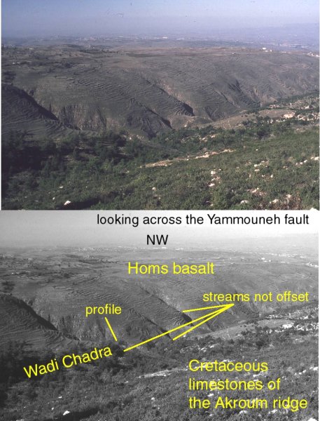
 Looking NW across the Yammouneh Fault. The viewpoint is on elevated
Cretaceous limestones, the offset eastern edge of the Mount Lebanon fold. We overlook
lavas of the Homs basalt which forms an incised lower plateau that leads off into
the distance. The Yammouneh Fault lies in Wadi Chadra, apparently offsetting the
lavas. However, the lavas occupy lower ground. The same map pattern is generated
if the Mount Lebanon uplift was offset AND THEN lavas erupted around the edges.
Evidence in favour of this second interpretation comes from the landscape. Minor
streams in Wadi Chadra are not offset, despite cutting through the entire fault
zone. There are no post-lava landscape features that appear offset.
Looking NW across the Yammouneh Fault. The viewpoint is on elevated
Cretaceous limestones, the offset eastern edge of the Mount Lebanon fold. We overlook
lavas of the Homs basalt which forms an incised lower plateau that leads off into
the distance. The Yammouneh Fault lies in Wadi Chadra, apparently offsetting the
lavas. However, the lavas occupy lower ground. The same map pattern is generated
if the Mount Lebanon uplift was offset AND THEN lavas erupted around the edges.
Evidence in favour of this second interpretation comes from the landscape. Minor
streams in Wadi Chadra are not offset, despite cutting through the entire fault
zone. There are no post-lava landscape features that appear offset.