| Return to location map |
The Bauges area lies between the cities of Annecy and Chambery. There is no detailed information on this part of the Subalps included as yet within these web pages. For Leeds users, the pop-up geological map of this area is on the Red Route corridor display case. You can locate the photograph below onto this map.
|
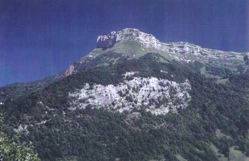
| Looking NE onto the hill of M. Margerie (1845m) from near Les Deserts. The lower cliff (Le Roc, top at c. 1000m) is made of Urgonian limestone (younging up). The woods above and behind this lower cliff contain Oligocene sediments which are overlain tectonically by a right way-up sequence of Cretaceous rocks, culminating in the prominent cliff of Urgonian limestone at the summit of La Margerie. |
| Return to location map |