Structural Geology
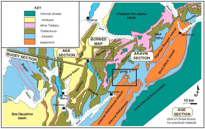
In this practical we will be working in the Alpine foothills - a region known as the Subalpine chains and the nearby Jura (type area for the Jurassic). The map below serves to locate the exercises. Use this, click on the headings below or scroll down the page to navigate into the four linked exercises. Make notes as you go and synthesise your findings.
| BUGEY | AGE | BORNES | ARAVIS | BACK TO START |
|
|
| Location map for this practical. The earlier practical location is also indicated (not a navigation button) |
This section, running WNW-ESE, comes from the edge of the Jura, a region known as Bugey. The western edge of the Jura is fault-bounded against a sedimentary basin of Tertiary age - the Bresse graben. Note: we will use this cross-section in a future practical to quantify deformation. PDF version of cross-section
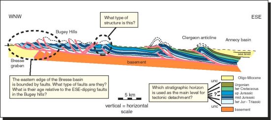
| BACK TO LOCATION MAP | BACK TO INTRODUCTION |
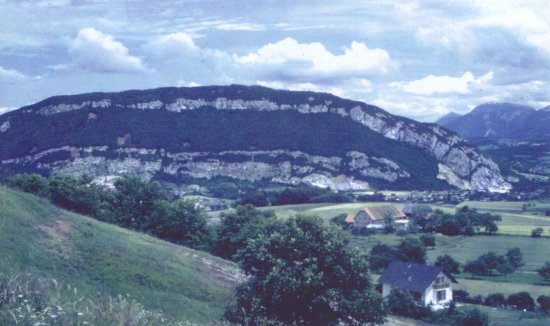 |
| The Montagne d'Age fold near Annecy, This view, looking NNE shows the Urgonian limestone with Jurassic limestones in the core. The Bornes massif is in the background. |
This structure, cropping out within the Annecy basin, is penetrated by a wellhole and is traversed by a gorge. We will re-examine this area, particularly making quantitative assessments of fault orientations, in a later practical.
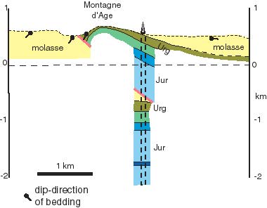
Use the geological information provided to complete the profile. You will need to consider the type of fault present in the section and thus predict the geometry of the adjacent wall-rocks.
| BACK TO LOCATION MAP | BACK TO INTRODUCTION |
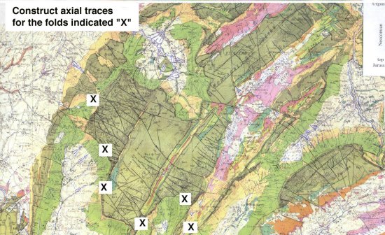
YOU NEED YOUR OWN HARD COPY OF THE GEOLOGICAL MAP
These hills, part of the Subalps proper, lie just to the NW of the city of Annecy. The prominent Cretaceous limestone, called the "Urgonian", picks out fold structures but is also cut by arrays of faults. We will re-examine this area, particularly making quantitative assessments of fault orientations, in a later practical.
Interpret the fold structures on the map (make a tracing using your own hard copy), annotating the synclines and anticlines. Note that a view links from the map. Are these folds upward or downward facing?. Assuming that these folds formed with hinges perpendicular to the direction of maximum compressive stress, label this/these orientations on the map.
We now turn our attention to the faults - particularly in the Urgonian forming the plateau near the Tete du Parmelan. Assess and label the likely orientations of the three principal stresses. What is the evidence on the map that these faults are steeply dipping?
| BACK TO LOCATION MAP | BACK TO INTRODUCTION |
The Aravis range contains a broadly continuous stratigraphic succession up from crystalline basement of the external Belledonne massif. However, in detail this succession is folded, as seen in the section. This shows the results of a hillside traverse where the dip and position of the main rock units were encountered. The shape (asymmetry) of minor folds in the Jurassic (mostly shales) is indicated. Additionally, an isolated outcrop was found in the valley bottom and this is shown in its correct structural position. All these pieces of information can be used to complete the cross-section. PDF version of section
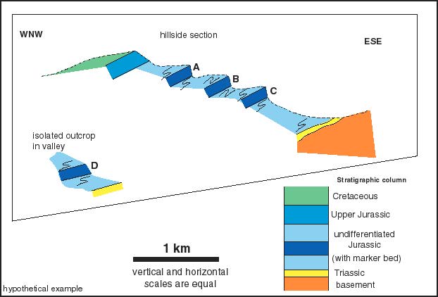
You should identify the vergence at the labelled locations (at the marker beds: A-D).
Once you have completed the section (drawn in the complete geometry of the Jurassic marker bed) you should answer:
What is the vergence AND facing of the MAJOR fold in the marker bed?
Do you think it could relate (i.e. be itself an asymmetric parasitic fold) to an even larger fold cored by basement of the external Belledonne massif (link back to the last practical)?
| BACK TO LOCATION MAP | BACK TO INTRODUCTION |
Make summary notes on all of these locations, particularly after completing the MCQ.
| BACK TO LOCATION MAP | BACK TO INTRODUCTION |