Link to map, cross-sections and photographs
ERIBOLL (NC485622 - 380501)
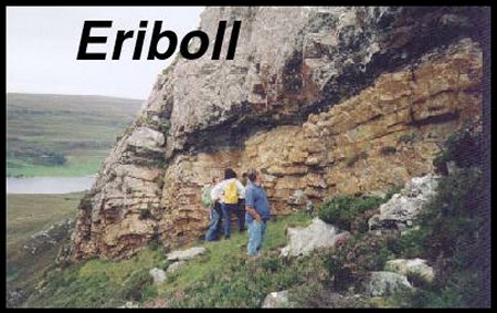
The readily accessible and compact outcrop areas of the Eriboll site provide excellent exposures of thrust architectures and related folds. These structures include sheets of Lewisian gneisses together with fine-scale imbrication of the Cambrian stratigraphy. Imbricate thrusting has caused repeated alternations of the main sedimentary units and resulted in the internal thickening of individual formations. The geometry of individual thrust surfaces and the constituent ramps and flats are clearly displayed in many locations. The relative sequence of thrust formation may be clearly established to be, in general, from top to bottom.
The range of structural levels allows study of the variations in fold geometry and deformation modes at an outcrop scale. Many of the structures have been developed in the Pipe Rock, which contains deformation markers to quantify bed-parallel shortening and shear strains. Hence in many parts of the Eriboll area it is possible to quantify the amount and type of finite deformation associated with thrusting and folding. As the Pipe Rock is almost entirely composed of quartz grains, it has provided a link between laboratory experiments in rock deformation carried out on monomineralic aggregregates and natural materials. The site is internationally important for understanding thrust tectonics and associated deformations from kilometric to grain scales. Thus the historical significance of the site is matched by its continuing importance in the study of structural geology and tectonics.
How Eriboll became the key to the thrust belt.
The site on the eastern and southern sides of Loch Eriboll site is of international importance for the historical development of concepts in structural geology and mountain building, particularly for thrust tectonics. The western flank of the sea loch is a spectacular dip-slope formed of Cambrian quartzites, one of the largest of such surfaces exposed in the British Isles. To the east and above the loch lies the Moine, separated by the Moine thrust belt. The region was originally critical in resolving the relationship between the Moine and the foreland Cambrian successions to the west (Lapworth, 1883). The Moine metasediments were emplaced tectonically upon the Cambro-Ordovician strata rather than forming a single coherent stratigraphic package, the result of 'prodigious terrestrial displacements' (Geikie, 1884). Peach et al. (1888, 1907) mapped out major thrust sheets of Lewisian basement and intricate arrays of imbricate thrusts. Indeed the term 'thrust' was first coined for these structures (Geikie, 1884). This recognition led to the adoption of a three dimensional approach through geological mapping and profile construction in understanding structural relationships rather than relying on reconnaisance transects alone.
The region has provided the examples for pioneering studies of quartz microstructures and deformation (White, 1979; Evans and White, 1984), used in understanding the rheology of fault rocks and for detailed petrofabric studies to establish strain paths in mylonites (Law et al., 1984). These studies have built from the seminal work of Lapworth (1883-4) at Eriboll from where the term 'mylonite' originates. On a larger scale, the ideal strain markers provided by the trace fossils in the Pipe Rock permitted studies of distributed deformation within thrust sheets to ellucidate emplacement mechanisms (Coward and Kim, 1981, Fischer and Coward, 1982; Coward and Potts, 1983). It has also been shown here that folds have only local significance (Butler 1982b) rather than have formed in a sequence that can be correlated in time (c.f. Soper and Wilkinson, 1975).
Structural summary
The Moine Thrust Belt at Loch Eriboll comprises, from structurally highest to lowest levels, the Moine thrust sheet, comprising mylonitised Moine metasediments and their Lewisian basement together with far-travelled, penetratively deformed Lewisian slices; mylonites derived from Lewisian gneisses together with Cambrian quartzites that formed their cover; thrust sheets containing Lewisian basement virtually unaffected by penetrative Caledonian strain (e.g. Arnaboll sheet) and variably imbricated Cambrian sediments.
Imbricated Cambrian strata are presumed to form the lowest structural level to the Moine thrust belt at Eriboll. However, the regional sole thrust lies submerged in the loch (but see the Foinaven site to the south). Within the site itself, the lower imbricates are best represented in the north, around Ben Heilam. These are dominated by Pipe Rock in the east with younger strata represented at structurally lower, western areas. The Heilam imbricates are structurally overlain by the Arnaboll Thrust sheet. This is formed mainly of Lewisian gneiss, little affected by post-Cambrian deformation. The gneisses form the crags of Creag Ruadh and Ben Arnaboll (NC485622 and NC 455590). However, the thrust has climbed section in its hanging-wall so that further west the Cambrian quartzites and younger units have been emplaced onto Durness Formation carbonates. The thrust runs offshore in Kempie Bay where it has lost stratigraphic separation. Consequently carbonates, which are generally poorly exposed, form much of the eastern side of Loch Eriboll around Eriboll Farm.
Lewisian gneisses of the Arnaboll Thrust sheet, showing virtually no penetrative post-Cambrian strain, are separated from the Moine mylonites by a tract of highly deformed quartzites and phyllonites derived from a Lewisian protolith (Rathbone et al., 1983). The mylonites have received considerable attention, initially in attempts to correlate deformation episodes and fold generations throughout the northern Highlands (e.g. Soper and Wilkinson, 1975). Although this approach has since been refuted, the relationships between folds, mylonites, distributed shearing and thrusting remain controversial.
As will be clear from the above description, the site is one of the largest and most structurally-complex in Scotland. This account concentrates on describing the detailed geology of several key localities.