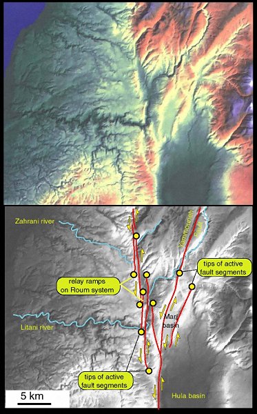
 Coloured and East-illminated Digital Elevation Model (created by
NPA Group) of southern Lebanon. The monochrome image shows the interpretation.
The main fault scars are clear on the image, particularly the segmented
Roum Fault system. River offsets (Zahrani and Litani) are classically used
to infer a northward reduction in slip on the Roum system. However, this
neglects possible stream capture. Presumably the ancestral Zahrani river
flowed in the unlabelled (dry) gorge to the south of the modern river.
Additionally, the Litani river originally flowed south into Hula. The modern
Litani and Zahrani courses are composit and and not merely offset by the
faulting. Full discussion of drainage evolution is given by Butler
et al. (1998).
Coloured and East-illminated Digital Elevation Model (created by
NPA Group) of southern Lebanon. The monochrome image shows the interpretation.
The main fault scars are clear on the image, particularly the segmented
Roum Fault system. River offsets (Zahrani and Litani) are classically used
to infer a northward reduction in slip on the Roum system. However, this
neglects possible stream capture. Presumably the ancestral Zahrani river
flowed in the unlabelled (dry) gorge to the south of the modern river.
Additionally, the Litani river originally flowed south into Hula. The modern
Litani and Zahrani courses are composit and and not merely offset by the
faulting. Full discussion of drainage evolution is given by Butler
et al. (1998).