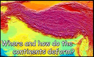
 The
Himalayan mountain range is high but has deep roots that provide isostatic
compensation. But the Himalayas are only the southern rampart of a vast
plateau - Tibet. Both have the same average elevation of just under 5 km above
sea level. The difference is that the Himalayas have more extremes (high mountains
and deep valleys) while Tibet is smoother. Both, and the other mountain ranges
of central Asia, are the surface manifestation of thickened continental crust.
This thickening presumably happened after India collided with Eurasia and continued
to move north. The plate tectonic data suggest
that between 2000 and 2500 km of convergence has happened since the continents
first came together. But how is this northward motion accommodated?
The
Himalayan mountain range is high but has deep roots that provide isostatic
compensation. But the Himalayas are only the southern rampart of a vast
plateau - Tibet. Both have the same average elevation of just under 5 km above
sea level. The difference is that the Himalayas have more extremes (high mountains
and deep valleys) while Tibet is smoother. Both, and the other mountain ranges
of central Asia, are the surface manifestation of thickened continental crust.
This thickening presumably happened after India collided with Eurasia and continued
to move north. The plate tectonic data suggest
that between 2000 and 2500 km of convergence has happened since the continents
first came together. But how is this northward motion accommodated?
A central concept in understanding collision mountain ranges is the idea of
a "suture" - or join - between the two
continents. It is generally agreed that the Himalayas are formed by crustal-scale
thrusting. This stacks up panels of crust. One of the
first thrust models - proposed 40 years before the
formal development of plate tectonics - was made by Emile Argand, the brilliant
Swiss geologist. Critically he suggested that India was pushed beneath Eurasia
- creating the Tibetan plateau. Another model, proposed in the 1980s by Philip
England and Greg Houseman, is that the Eurasian side of collision thickened
up, with relatively little stacking on the Indian side. Yet another model, advocated
by Paul Tapponnier since the 1970s, is that Eurasia
is being squirted eastwards and India acts a near-rigid indenting ram.
We can test between these models. First off, we can investigate if deformation
is concentrated to the north of the suture (Asian side, as the England-Houseman
and Tapponnier models both suggest) or on the south (Indian side, as required
by the Argand model). Click here for setting up the test.
The key information comes from information on the palaeolatitude of the southern
edge of the Tibetan crust (a chunk of crust called the Lhasa block, named after
the Tibetan capital), which comes from palaeomagnetic studies. Click
here for these results. What do the data imply?
If most of the convergence is accommodated on the Asian side we now have to
choose between the two models of thickening vs squirting (extrusion). We can
use the earthquake data and
the topography. Interestingly these give opposite
results. The seismicity show the Tibetan crust not to be thickening but thinning
in an east-west direction. So this looks like it's being squirted sideways.
But this doesn't explain the topographic elevation of the Tibetan plateau -
and hence its great crustal thickness. Perhaps a compromise is needed - with
the crust thickening up at first but now it is spreading out sideways. Even
Argand was partly right, because the Himalayas are telling us that the Indian
crust is being stacked up. All this shows how complicated orogeny can be. Most
critically - the end result is that deformation in the continents is far most
complex than in the oceans. Plate boundaries are marked in the continents are
broad areas of strained crust (picked out by the wide tracts of seismicity)
while the oceanic plate boundaries are narrow (as seen in the earthquake
map)
We can see how rocks respond to all this orogeny by visiting outcrops on a natural
section through the Pakistan Himalayas - up the Karakoram
Highway.
Himalayas front page