
News
- Home Page
- About the Afar Rift Project
- About the Consortium
- About the Afar Region
- Geology of the Afar Region
- News
- Results and Publications
- Fieldwork Campaigns
- Information for Schools
- Photo Gallery
- Links
- Contact Us
- For Consortium Members
Successful February 2010 Field Campaign
BGS team
The BGS mapping team conducted two periods of fieldwork in February and March. The first campaign was conducted alongside the Seismic team and involved the collection of samples all over Afar, from the western rift margins to Semara and northward to Erta Ale. The purpose of these samples is to groundtruth the composition of units seen in remote sensing imagery and use the interpretation of these sites to extrapolate geological linework into areas that we cannot reach. On the second period of work BGS joined a team from CNRS-Nancy, France into the centre of the northern rift segment on the southern flanks of Dabbahu volcano. Detailed fieldwork was conducted on the nature of basaltic lava flows, stratigraphy and the relationship between Dabbahu and rift axis fissural volcanism. Further samples were also collected here to identify any petrologic relationship between the two styles and periods of volcanism in this area.
MT team
During the recent field campaign the MT team collected data from two distinct regions of the rift. First, six new sites were deployed between Digdiga and Barantu: a 30 km long profile trending northwards parallel to the active rift and passing as close as possible to Badi and Dabbahu volcanoes. The data look to be of high quality, and we hope that they will allow us to image magma reservoirs which directly supply the volcanoes and on going dyking events.
The second area visited was 20-30 km north of Semara, the regional capital, where an intriguing area of subsidence had been detected by satellite observations. Some of this area, called Saha, was flooded due to heavy rain several weeks prior to our arrival, but with careful navigation using our satellite image we managed to get to within a few kilometres of our desired locations. Four sites were occupied between here and our 2009 profile, and again we hope to detect something (magma?) which may explain the subsidence seen in the InSAR.
Both new sets of data will be used to build up 3D models which will be based around the 2008 and 2009 MT profiles which cross the rift.
Nick Johnson's photos of the fieldwork (right).
Congratulations to Professor Gezahegn Yirgu
4th February, 2010. Congratulations to Professor Gezahegn Yirgu on his promotion to Full Professor of Earth Sciences at Addis Ababa University.
Geology is slow, right? Wrong!
Afar Rift Consortium at the Royal Society Summer Science Exhibition
The Afar Rift Consortium has been chosen to present a stand on our work at this year's 350th Royal Society Summer Science Exhibition. We are one of only 26 groups from a field of 160 to be selected. The exhibition runs from Saturday 26th June to Sunday 4th July at the Southbank Centre. More details to follow.
Royal Society Summer of Science
New Eruption in the Dabbahu Segment, Afar (28-29 June)
On Monday 29th June a new sulphur dioxide cloud was detected by NASA’s EOS-Aura satellite over the southern Afar region. The cloud appears to originate from the Karbahi region of the Dabbahu (Manda-Hararo) rift segment, near to the site of previous fissure eruption in August 2007. The sulphur cloud is a similar size to that of the August 2007 eruption. Hot lava was detected by heat sensitive instruments on NASA’s Terra and Aqua satellites. Meteosat’s fire detection sensor suggests the eruption began at around 17:15 GMT on 28th June, about 7 hours after a magnitude 4.4 earthquake, reported by the European-Mediterranean Seismological Centre.
A team from the Consortium has flown straight out to Afar and hope to visit the eruption site with scientists from Addis Ababa University and the Ethiopian Geological Survey to collect rock and gas samples, as well as photographic and thermal imagery. One of the team, David Ferguson, is keeping a blog of his experiences on the Guardian website http://www.guardian.co.uk/science/blog/2009/jul/03/volcanic-eruption-afar-ethiopia
The Afar region remains one of the most active geological areas on the planet, and the ongoing rifting episode has included the intrusion of 13 volcanic dykes to date. Three of these have resulted in volcanic eruptions but the rest have remained below ground. A separate eruption occurred on the Erta ‘Ale range in November 2008. For more technical information about the ongoing activity see our publications.
We anticipate that further eruptions will occur in the coming years, as the tectonic strain is fully released (Hamling et al., 2009 (PDF file)).
Field report from the eruption site (pdf file)
Photographs from the field of the eruption site
Notes for editors:
1. The Afar Rift Consortium is an international, interdisciplinary collaborative
project funded by the Natural Environment Research Council in the UK and
the US National Science Foundation. It comprises scientists in the UK,
US, France and Ethiopia.
2. Sulphur dioxide measurements were made using the OMI instrument on
NASA’s EOS-Aura satellite: http://satepsanone.nesdis.noaa.gov/pub/OMI/OMISO2/
3. Hot lava is routinely detected by the MODIS instruments on NASA’s
Terra and Acqua satellite, and processed using the MODVOLC algorithm at
the University of Hawaii: http://modis.higp.hawaii.edu
Previous News Items
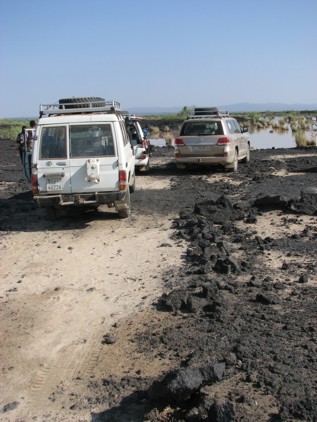
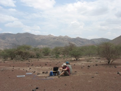
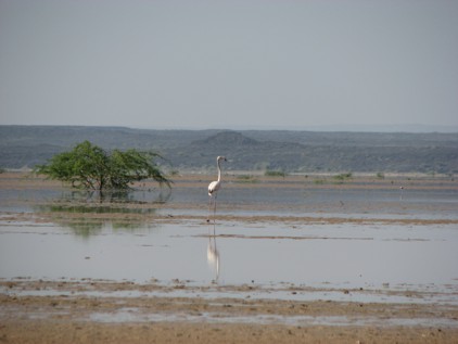
Photographs of the February 2010 MT fieldwork campaign. Top and middle: At Badi Volcano. Bottom: A flamingo. (Nick Johnson, University of Edinburgh)
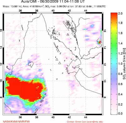
Figure 1: Images of sulphur dioxide emissions taken on 30th June, 2009 from the OMI instrument on NASA’s EOS-Aura satellite. Simon Carn, Michigan Technological University, NOAA Satellite and Information Service (http://satepsanone.nesdis.noaa.gov/pub/OMI/OMISO2/)
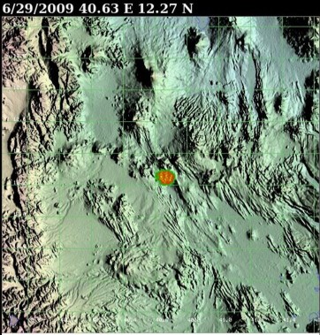
Figure 2: Heat sensitive image from NASA’s Terra and Acqua satellite taken on 29th June, 2009 (http://modis.higp.hawaii.edu)