
Danakil and Ali-Sabieh Blocks (non-technical)
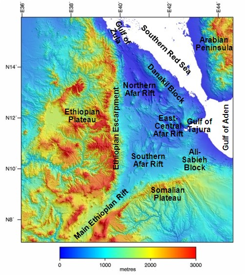
Digital elevation map of the Afar region showing the main structural divisions.
Geology of Danakil and Ali-Sabieh Blocks
Danakil Block
On the eastern edge of the Afar Depression and separating it from the southern Red Sea is the narrow, northwest-trending Danakil horst (high ground bounded by faults) or microplate. It is a ridge about 500km long, 100km wide and on average 400m high of Precambrian basement (about 900 million years old) overlain by Oligocene to recent (35 million years to present day) lavas from the Afar flood basalt province. Originally, the Danakil block lay against the Ethiopian plateau on the western Afar margin but about 20Ma as the Somalian, Arabian and Nubian plates began to rift apart it broke away from the Plateau. It has continued to move to the east/northeast relative to the Plateau as the Afar rift zone has opened up. To the south of the Danakil block is the Asal-Ghoubbet rift along which the Gulf of Aden rift is propagating into the Afar region.
Ali-Sabieh Block
The Ali-Sabieh Block (aka Aysha’z, Aysha or Ali Savieh block) extends northwards from the Somalian Plateau. Prior to the propagation of the Gulf of Aden through the Gulf of Tajura and Asal-Ghoubbet rift this area was continuous with the Danakil block. It has a lower elevation than the Somalian Plateau and is an area that has been thinned, extended and rotated during rifting but has remained attached to the Somalian plate. There are a series of north-south trending volcanic spatter cones and large faults along the western edge of the block which may have developed as it was rotated relative to the Somalian Plateau.
For references used, please see technical version.